
Wikitude Drive enhances GPS navigation with augmented reality
 Mobilizy, makers of the Wikitude Augmented Reality (AR) apps for iPhone, Android, and Nokia phones, came up with Wikitude Drive – a mobile AR satellite navigation system with global coverage which could take the current driving experience with GPS a step further, because you may no longer have to follow audio directions and look at maps on your screen.
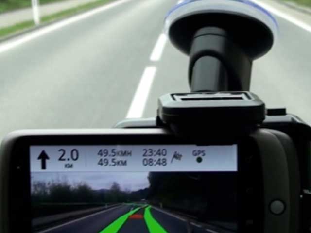
Driving directions not only appear on screen, they are overlaid on the live video stream of the very street you are driving on. As a result, you are seeing the real world and real road in front of you, while being directed by a digital route layered on top of it. There is no doubt there will be requirements for some tweaks of the system and that’s why the folks at Mobilizy started to beta test their system.
So, what makes this system different from its predecessors? First, due to the overlaying of the route onto the live video stream of the surroundings, the driver can easily recognize and follow the suggested route. Instead of looking at an abstract map you are looking at the real world (hopefully without many real world-data mismatches). The navigation system leads the driver through unfamiliar territory in a natural, real and easy way.
Secondly, Wikitude Drive solves a key problem that all other navigation systems have. These systems require the driver to take his eyes off the road in order to look at the abstract navigation map. Just by looking at the map screen for one second when driving at 100 km/h (62 mph), the driver is actually “blind” for 28 meters (92 ft). Think about how much can happen in those precious meters. Since Wikitude Drive provides you with driving directions on top of the live video stream, you still see what is happening in front of you when looking at the display of your mobile AR navigation system.
In some driving conditions however, for example when driving in the dark, a traditional map is in fact more helpful. With just one tap on the cell phone’s touch screen, you can switch between the Augmented Reality view and the traditional 3D map-view. To give you additional navigational directions, voice commands are provided as well.
Currently, it works only on Android phones (OS 1.6 and newer) which are able to run more than one app at a time and it is being tested in USA (although they claim to plan to expand their testing to other countries). Navigational data comes from Navteq, a global supplier of mapping and routing information. A future version of Wikitude Drive will integrate with Wikitude World Browser to offer millions of Points of Interests to leverage the full power of the Internet and user generated content.


Leave your response!